STOP HITTING UTILITIES CALL A PRIVATE UTILITY LOCATOR BEFORE YOU DIG IN PURSUIT OF 100% SUBSURFACE DAMAGE PREVENTION
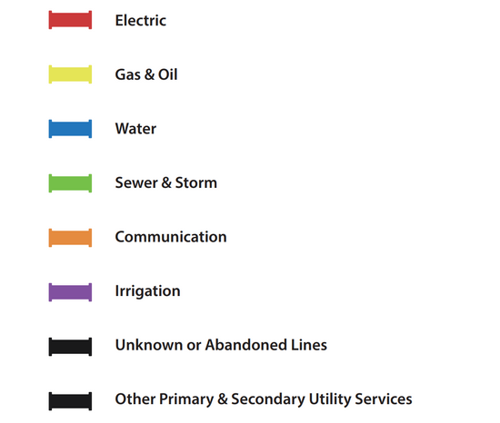
Electric | Gas & Oil | Water | Sewer & Storm | Communication
Underground private utility locating is critical to any construction project where subsurface excavation is planned, and is beneficial even when excavation isn’t planned. The excavation team and property owner are responsible for locating and avoiding any underground utility lines, public or private, beneath the construction site. Failure to accurately map and avoid these utility lines can result in expensive damage, costly delays, and potential injuries or even fatalities to your excavation team as well as the general public.
There is a utility strike every 60 seconds in the U.S. That number is startling, and hasn’t slowed down, despite greater understanding and use of 811. These hits are not only dangerous for life and limb, but also for budget. Labor costs to fix construction mistakes costs $177.5 billion dollars per year, and utility strikes are estimated to account for some $40 billion of that number!
At GPRS we believe that data control = damage control and we are committed to the pursuit of 100% subsurface damage prevention – on every job, in every market, nationwide.
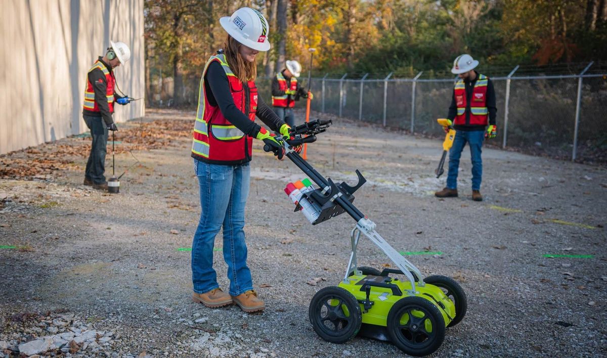
That’s why every one of our 500 national “boots on the ground” team of elite Project Managers are trained extensively in a multitude of ways, including in Subsurface Investigation Methodology (SIM). SIM elevates a mere technician to an expert professional with the cross-technology training and industry-leading processes that can locate, map, capture, measure, and scan your entire site or facility, above and below-ground, to provide you with the real-time actionable information you need to plan, design, manage, dig, and build better.
GPRS guarantees an enjoyable and smooth field-to-finish process with 99.8% accuracy. Our skilled Project Managers employ various advanced tools for data collection, including ground penetrating radar, CCTV cameras, and LiDAR, among many others. In-house mapping creates deliverables stored in SiteMap® (patent pending). Upon utility locate completion, SiteMap® houses and delivers layered, interactive utility maps in .pdf, .kmz, and .shp formats as part of your complimentary SiteMap® Personal subscription.
GPRS TAKES THE GUESSWORK OUT
GPRS provides comprehensive and accurate utility maps of every utility on the site, whether they are public or private. Your utility map will include depths wherever possible – and can be exported into a wide variety files that provide seamless communication and collaboration on any project. GPRS provides a complimentary PDF, .KMZ file, and a SiteMap® Personal subscription with every outdoor utility locate.
UNHEARD OF PRECISION- GPRS PROVIDES 99.8% ACCURATE DATA
Underground Private Utility Locating
Exceptional Utility Locating
GPRS provides full-service utility locating to help keep your projects on time, on budget, and safe. GPRS offers a variety of relevant services including:
Facility Mapping Services
GPRS’ mission is to Intelligently Visualize The Built World® for our customers. We are visualizing the world around us one job at a time. We provide comprehensive above and below ground facility and infrastructure mapping for many different industries. Our services provide accurate 3D BIM models, 99.8% accurate utility locating & concrete imaging via GPR, NASSCO-certified Video Pipe Inspection (CCTV) reports, 2D CAD drawings via FLRPLN, Conceptual Site Models (CSM), rectified 3D photogrammetry via ProCap and even 3D virtual tours via WalkThru 3D. If there’s a facility you need mapped, GPRS can map every inch with startling accuracy.
Directional Drilling Clearance
When installing fiber and telecommunication lines, you have to know where to drill or you’ll risk striking existing underground utilities. Cross bores that are commonly caused by trenchless technology put utility infrastructure and community safety at risk. Avoid damages while also confirming the safety of your work with pre and post-installation cross bore inspections that capture accurate existing conditions underground before you drill, while also confirming the safety of your completed work.
Environmental Due Diligence & CSM
GPRS provides assistance in Phase I and Phase II Environmental Site Assessments (ESAs), whether for due diligence before a sale or when tracking potential contamination for regulatory concerns. We provide some of the most accurate utility locates on the market, these locates map preferential pathways for contaminants. We can also provide detailed and accurate conceptual site models (CSM) for 3D site visualization.
One Call Locating Services
Calling 811 before you dig is the law, and One Call will connect you with public utility contractors who will provide you with the location of all public utilities near your excavation. While this is fantastic, One Call cannot provide locates for the private utility lines on site. They also cannot provide depths for public utility lines. GPRS elite private utility locating can locate both public and private utilities, while providing accurate field markings, including depths. We also give you complimentary digital and PDF utility maps of your utility infrastructure, including a personal subscription to our GIS platform, SiteMap®.
UST Locating
Finding underground storage tanks (USTs) on any site is crucial to remediating major risk before excavation. Imagine a parking lot littered with landmines, wouldn’t you want to locate where they were before you dig? Abandoned tanks and lines can be easily found and comprehensively mapped by our SIM-certified Project Managers. Further, our talented Mapping & Modeling team can create a comprehensive map and/or conceptual site model (CSM) of your facilities for risk mitigation and recording purposes.
Soil Boring Clearance
Environmental consultants and other professionals require soil borings when providing due diligence in a property transfer or when investigating environmental hazards in contaminated areas and brownfields. Knowing what utilities, features and anomalies exist underground before you drill can help mitigate additional damages and risk in an already hazardous situation.
Utility As-Built Creation
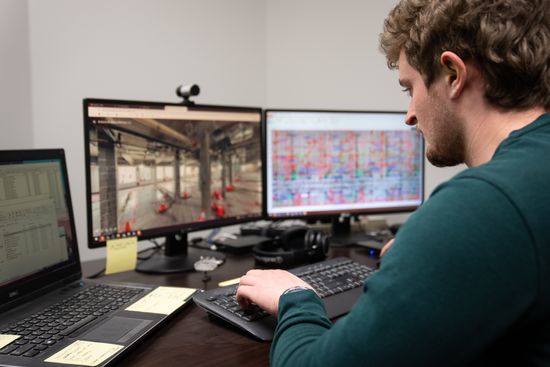
GPRS provides a complimentary PDF, .KMZ file, and a SiteMap® Personal subscription with every outdoor utility locate. Our highly trained, elite Project Managers utilize the data from your utility field markings to create digital, layered utility maps inside SiteMap®, and our in-house Mapping & Modeling Team can provide you with TruBuilt plan views. We can even create a comprehensive 3D BIM or Conceptual Site Model (CSM) that accurately visualizes your entire utility infrastructure to communicate, collaborate, and manage your project or facility better, with the right information.
GPRS HAS MAINTAINED A 99.8% ACCURACY RATE ACROSS OVER 500,000 JOBS NATIONWIDE
Private Utility Locating
GPRS can go everywhere 811 does, and where they don’t. Because 65% of utilities are private utilities, it’s important to go beyond 811. 811 may not be able to locate these utilities for you, but GPRS can, providing accurate, detailed maps and data that can be used in a variety of ways.

Utilities That Can Be Located
What Utility Lines Can Be Identified?
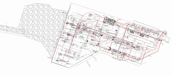
GPRS offers you a comprehensive range of utility locating and reporting options, from marks on the ground to basic field sketches to comprehensive CAD reports identifying buried electrical, water, gas, communication, sewer, and storm drain lines, and so much more. Our state-of-the-art technology and expert Project Managers will provide you with an accurate location record for future reference. Even better, you also get instant access to our easy to use, detailed GIS platform SiteMap®, allowing you to access and share your aggregated maps wherever you are. Your site data is stored for the lifetime of your project, and is accessible only to those you give access to.
Our service is second to none. We utilize an array of technologies to pinpoint subsurface utilities, map their locations and develop detailed PDF and dynamic geolocated reports for our customers.
Technologies & Methods
Ground Penetrating Radar
EM Locating - Active
EM Locating - Passive
Electromagnetic Induction (EMI)
Robotic CCTV Crawlers
Push Camera
CCTV Lateral Launch Cameras
Sondes
Acoustic Leak Detection
Leak Detection Correlators
At GPRS, we’re always looking for the next best technology or method- pushing us further towards our goal of 100% subsurface damage prevention.
Utility Locating & Injury Prevention
Safety and injury prevention are the top priorities at GPRS, as it is for our many clients. Safety is at the core of our services and something we take great pride in. If a utility line is damaged or compromised, your team can be exposed to danger from live electrical lines to gas and sewer utilities. An ounce of prevention, such as accurately mapping and locating the utility lines buried beneath your job site, can save you time, money and keep your construction safe.
GPRS Project Managers are put through rigorous training. Through the GPRS Safety Program, OSHA classes and certifications, operator qualifications, The GPRS Academy, Fall Protection Training, Confined Space Training, CPR Training, First Aid Training and Classes, ERail Safe, and countless site other specific trainings beyond their SIM certification, we are confident that our Project Managers will locate your subsurface obstructions safely and accurately.
GPRS’s focus on safety has earned us an impressive record. Our 2018-2019 Experience Modification Rate of 0.47 is substantially better than the industry standard of 1.0.
GPRS Project Managers are always looking to improve their abilities with the various equipment we use.
SIM - SUBSURFACE INVESTIGATION METHODOLOGY:
SIM is the standard operating procedure that GPRS follows, comprising two specifications created specifically for subsurface investigations. One is for underground utility locating and the other is for concrete scanning.
SIM, which is short for Subsurface Investigation Methodology, is a guide to using the locating technologies of an electromagnetic receiver and GPR technology combined with a proven training approach to achieve a very low investigation error rate. SIM does not involve the practice of geophysics, geology, land surveying or engineering.
SIM contains three primary elements, the human asset, technology asset, and methods applied in the field. The ultimate site results are accomplished when an experienced and trained field technician can utilize multiple technologies in a comparative analysis of results from each technology. Therefore, highly skilled technicians can locate the same target using multiple technologies resulting in confirmation of findings and results.
Our utility detection services can locate public and private utilities across a wide variety of industries. We help utility contractors and other construction workers avoid accidental strikes, which is one of the most common sources of construction-related injuries. We do so by precisely locating utilities, and then providing accurate and easy to understand maps and data which can be used in multiple ways to represent the site at hand.
Injury prevention is critical for employee safety and keeps projects on time and on budget. GPRS takes your safety seriously, accurately and efficiently locating every inch of utility, saving you time, money, and catastrophe.
5 Cost Factors in Your Utility Locating Project

How Complex Is Your Utility Locating Target?
Is utility congestion high or low in the area?

The Type And Quantity Of Utilities Being Located
- This includes water, power, gas lines, sanitary and storm sewers, and other critical subsurface utilities.

The Size Of The Area That Is To Be Inspected
- The larger the area that requires utility scanning, the more significant the potential impact on cost.

The Scope And Detail Required For The Project
Simple painting/flagging utility locations is at one end of the cost spectrum, while requesting detailed AutoCAD reports of our findings is at the more expensive end. Other options to help control costs include field sketches and Google Earth imaging.

Difficulty Of Site Access
If there are limitations and restrictions to when we can access the project site in terms of days and times, it will impact the project’s cost.
Analyzing 3D scans
Analyzing 3D scans
Utility Location Markings & Deliverables
The services and products offered by utility locating companies may vary from company to company, so it is essential to know what is provided.

Field Markings
Field Markings
Physical Markings Or Flags
Field markings are often applied in the form of paint, pin flags, stakes, or any other method requested by clients. Project Managers trained by GPRS ensure that all field markings applied are clear and understandable. Each GPRS Project Manager creates a GPS mapping sketch for our automated utility locate delivery service.
SiteMap® Subscription
Better manage your job site or facility with our easy to use GIS software platform, SiteMap®. SiteMap® allows you to quickly access, view, and share your infrastructure data securely with subcontractors, engineers, and your team. All of your utility, structural, water & sewer, and facility information is uploaded into the SiteMap® Map Viewer and Digital Plan Room. When you hire GPRS, your data is automatically uploaded to your complimentary SiteMap® Personal Subscription, and you’re given the opportunity to upgrade to access even more features.
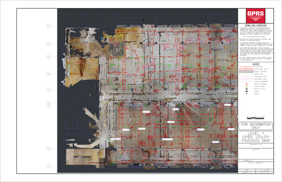
PDF file shows utilities' locations visually.
PDF file shows utilities' locations visually
PDF & KMZ Maps
Knowing the difference between a KMZ file and a PDF map is essential. A PDF file shows utilities' locations visually. PDF files are like paper maps that you can view on a computer or monitor. KMZ files, on the other hand, include geolocated points indicating specific utilities, lines, and other features. Every utility locating project from GPRS is accompanied by a complimentary pdf map and kmz map.
Space can be modeled in 2D or 3D in CAD files.
Space can be modeled in 2D or 3D in CAD files
CAD Renderings & 3D Models
The space can be modeled in 2D or 3D in CAD files. As-built drawings are developed or updated using this service, which contractors and engineers can use. CAD and GIS systems are used by clients for preplanning, avoiding utilities, or documenting their site history. We can generate CAD files documenting our outdoor utility locating results through the GPRS Mapping & Modeling Team and delivered via SiteMap®.
6 Frequently Asked Questions About Ground Penetrating Radar Utility Locating Services
Can GPRS Find Plastic Pipes?
Yes. The technology and expertise applied to your project site allow for discovering the varying pipe compositions existing in the industry.
Can GPRS Determine the Type of Utility it Has Located?
Our equipment can’t determine the type of utility we’ve found, but often our Project Managers can. With their experience and knowledge, they can trace the line to where it surfaces and determine its type. We can even locate the depth of your utilities.
How Accurate Is Your Utility Locating?
GPR is highly accurate! In fact, we have maintained a 99.8% accuracy rating over 500,000 jobs nationwide. This rating is verifiable, backed by intricate technology use and highly trained elite Project Managers who carefully and skillfully locate all aspects of your site. While GPRS just may be the most accurate on the market, it’s important to note that variables such as ground and soil conditions affect accuracy. Regardless, GPRS Project Managers are trained on mitigating these potential issues. We've found that when using a standard concrete antenna for scanning, the result is typically +/- ¼" to the object's center and +/- ½" to the depth. When locating using a utility locating antenna, the accuracy is +/- 6" to the center and +/- 10% to the depth.
Can We Get A Permanent Record Of Your Findings?
Yes. We can provide you with a field subsurface utilities markings map and a detailed AutoCAD report.
How Large Of An Area Can Be Scanned For Utility Locations In One-Day?
The size of the area that can be accurately located in one-day will vary based on the project site itself. Vacant/green fields many acres in size scheduled for residential development can be accurately located with great speed as the expected congestion of utilities is low. On the other hand, a small property (less than one acre situated on a busy metropolitan street) could be time-consuming as the anticipated high utility congestion.

Are Saturated Soils or A High-Water Table Detrimental to Ground Penetrating Radar Results?
It can be. While the equipment used by GPRS is effective, it can be inhibited by moisture. It is best to contact your local expert GPRS Project Manager for more information on the soils native to your project.
State Agencies Vs. Private Utility Locating Services: Know the Difference!
To prevent utility strikes, states offer a free utility locating service to anyone excavating. It's the contractor's responsibility to call 811 rather than risk this subsurface damage. In different states, 811 services are known by various names, such as Digline, Onecall, etc. 811 services are exclusively for public utilities. Private utilities are not included.
Public utility services include water, electricity, gas, communications, and sewers. In contrast, it is no longer considered a public utility once a line is connected to a private facility. The 811 service is often in high demand since it is required for every new construction project. While 811 services offer a base level of information, they do not provide as much detail as needed. GPRS can go deeper and may offer more detailed information, such as the depth of the line, abandoned lines, etc. 811 typically cannot provide high-quality digital maps or deliverables that private companies like GPRS can.
Clients should contact both public and private utility locators for best practices, such as GPRS.
GPRS provides subsurface damage prevention services, including:
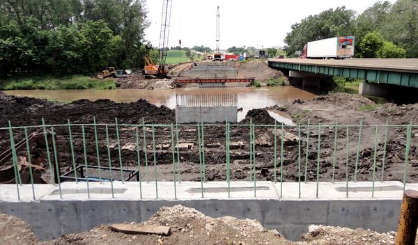
Utility Locating At Road Construction - Highway Bridge
Clients should contact both public and private utility locators for best practices, such as GPRS. GPRS provides subsurface damage prevention services, including:
Schedule a Project Today
GPRS offers an accurate, precise way to see the subsurface and the world around you. We are on a mission to Visualize the Built World, and we want to help you be a part of it. Our Project Managers have the skills and equipment to handle any subsurface challenges. GPRS uses various advanced locating technologies in conjunction with world-class SIM protocols.
Go deeper with GPRS, contact us today.
Don't wait. To schedule a project with GPRS, click here. Our highly trained Project Managers will keep your project on time, on budget, and safe.