Accurate Subsurface Documentation at Gavilan College: How GPRS Utility Locating and SiteMap® Delivered Reliable Data Across 150 Acres
Maintaining and upgrading aging campus infrastructure demands precise, verifiable subsurface information. When Arizona Pipeline Co. initiated a water line installation project across Gavilan College’s 150-acre campus in Gilroy, California, the absence of reliable as-builts presented a critical risk to project timelines, budgets, and safety. To address these challenges, Arizona Pipeline turned to GPRS for precision utility locating services and digital record creation through SiteMap® (patent pending).
Background: Gavilan College’s Infrastructure Challenges
Originally founded in 1919 as San Benito County Junior College, the institution operated out of Hollister High School before relocating in 1966 to its current campus following the establishment of a new community college district and the passage of a local bond measure. Like many campuses developed in the mid-20th century, Gavilan lacked accurate and updated utility documentation. Facilities managers were left with incomplete records, creating significant unknowns for contractors preparing to excavate.
Without accurate subsurface documentation, higher education facilities are exposed to increased risk of project delays, safety hazards, utility strikes, and unforeseen costs. These risks necessitate a proactive approach to existing conditions verification before commencing any underground work.
Precision Utility Locating: GPRS & Subsurface Investigation Methodology
Arizona Pipeline initially engaged GPRS to locate a single buried water line critical to their trenching operation. GPRS Project Manager James Turrentine applied the Subsurface Investigation Methodology (SIM) approach utilizing ground penetrating radar (GPR) scanning and electromagnetic (EM) locating to accurately identify the water line’s position.

GPRS Project Manager James Turrentine, a smiling, dark-haired young man dressed in a black GPRS-branded polo shirt, and a Carhart knitted cap.
GPR scanning involves transmitting radio waves into the subsurface and analyzing the resulting reflections caused by underground structures such as pipes, conduits, and storage tanks. The reflections are displayed as hyperbolas on a GPR readout, which trained GPRS Project Managers interpret to determine the precise location and depth of buried utilities.
In parallel, Turrentine employed EM locating to identify electromagnetic signals emitted by metallic utilities. These signals may originate from a locator’s transmitter applying current directly to a pipe or cable, from current flow in live electrical systems, or from metallic pipes acting as antennas for stray electrical fields and communication transmissions. EM locators, operating in Power Mode or Radio Mode, detect these variations and allow for a detailed mapping of conductive underground features.
By integrating GPR and EM technologies, GPRS ensured a comprehensive view of the subsurface environment. Once located, Turrentine marked utility locations physically on the site with flags and paint, while simultaneously documenting the findings digitally in SiteMap® (patent pending), GPRS’ proprietary utility mapping platform.
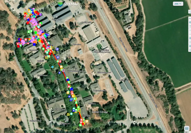
SiteMap®: Delivering Secure, Verifiable Infrastructure Records
GPRS delivers accurate subsurface utility and other data via SiteMap. In this case a layered, interactive map of the campus’ utilities, which will help the Facilities and Operations teams greatly reduce utility strikes when excavating.
SiteMap® offers facilities and operations managers a centralized, interactive platform to access verified subsurface utility data. Accessible 24/7 from any computer, tablet, or smartphone, SiteMap provides a secure single source of truth for project teams across planning, excavation, maintenance, and future renovations.
By capturing and uploading Gavilan College’s infrastructure data into SiteMap, GPRS not only eliminated reliance on outdated or missing as-builts but also provided a reliable foundation for ongoing and future campus development. Facilities managers gained a verifiable record that directly mitigates risk and improves operational efficiency.
“[Turrentine] showed them in SiteMap their scope of work that they called us out there to do,” said GPRS Area Manager Jake Wright. “And [the client] said ‘Oh wow, we actually have hundreds of [utility] trenches we need to do. Could we do the whole campus like that?’ And Turrentine said ‘Yeah, totally.’”
Scaling to a Full-Campus Utility Survey
After reviewing the initial utility locating results presented through SiteMap, Arizona Pipeline immediately recognized the value of complete, accurate subsurface documentation. Their team requested that GPRS expand the scope to locate and map all buried utilities across the entire Gavilan College campus.
Rather than operating reactively and risking costly utility strikes, Arizona Pipeline and Gavilan College’s facilities team chose to act comprehensively. By doing so, they established a verifiable record of their entire underground utility network—a critical asset for all future maintenance, renovation, and expansion efforts.
GPRS provided Arizona Pipeline with SiteMap Project access, enabling full team collaboration with field-verified data for the duration of the project. SiteMap’s interactive mapping tools allowed stakeholders to make informed decisions confidently, improving excavation planning, safety compliance, and resource allocation.
Verified Existing Conditions Are Critical for Higher Education Facilities
For facilities and operations managers in higher education, the Gavilan College project demonstrates the vital role that verified existing conditions play in managing complex, aging infrastructure systems. Without current, accurate utility data, institutions risk exposure to significant financial, operational, and safety liabilities.
Through the application of advanced GPR and EM locating technologies, combined with digital documentation via SiteMap®, GPRS provided Gavilan College and Arizona Pipeline with the situational awareness necessary to execute infrastructure projects safely and efficiently.
From sprawling campuses to vertical urban developments, GPRS Intelligently Visualizes The Built World® to support facilities teams in safeguarding their infrastructure assets. By partnering with GPRS and leveraging SiteMap®, colleges and universities can future-proof their operations, minimize downtime, and maximize capital project success.
What can we help you visualize?