What to Expect When You Order an Underground Utility Locating Survey
Here’s what AEC professionals should expect when they hire a local utility locating company near them to conduct a subsurface utility assessment, based on GPRS’ processes.
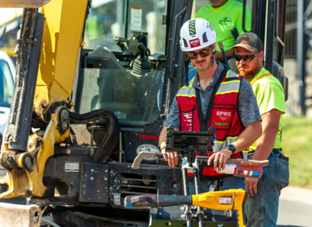
A GPRS Project Manager utilizes a large GPR unit to scan for subsurface utilities prior to excavation.
General contractors and facilities managers face significant risks when undertaking excavation projects of any size. If subsurface utilities are not properly identified, projects can suffer costly delays, infrastructure damage, and safety hazards for workers and the surrounding community. GPRS specializes in high-accuracy subsurface utility location surveys to mitigate these risks. This article outlines what AEC professionals should expect when hiring a private utility locating company, based on GPRS’ processes.
The Difference Between a General Underground Utility Assessment and S.U.E.
GPRS provides private utility locating and mapping services that support Subsurface Utility Engineering (S.U.E.) Level B investigations, but does not conduct S.U.E. itself. Licensed S.U.E. surveys involve engineering assessments and regulatory compliance, which GPRS complements by specializing in utility detection, location, and mapping using ground penetrating radar (GPR), electromagnetic locators, and CCTV video pipe inspection crawlers and push cameras. These technologies allow GPRS to identify underground utilities with 99.8% accuracy.
GPRS prioritizes nationwide rapid response scheduling and non-invasive utility locating, ensuring that contractors and facility managers receive precise, real-time data without costly excavation delays or utility strikes. All GPRS Project Managers are certified in Subsurface Investigation Methodology (SIM), which ensures repeatable and reliable results across all projects.
GPRS utility mapping provides contractors and facilities teams with comprehensive utility data, reducing risk and improving efficiency—helping to execute successful projects. Additionally, GPRS delivers findings via SiteMap® (patent pending), a GIS-based platform that enhances collaboration and decision-making with RTK geolocated, layered, and interactive utility maps, NASSCO-certified video pipe inspection reports, and reality capture deliverables that integrate subsurface and structural data.
Subsurface Investigation Methodology (SIM),
Subsurface Investigation Methodology (SIM)
methodology minimizes the risk of utility strikes, which can cause safety hazards and financial losses. GPRS Project Managers nationwide follow SIM to guarantee precision and reliability in every assessment.
Equipment Used in Subsurface Utility Surveys
GPRS deploys a combination of advanced technologies to achieve 99.8% accuracy in utility detection and mapping, including:
- Ground Penetrating Radar (GPR)
GPR transmits high-frequency radio waves into the ground. When these waves interact with different subsurface materials, they reflect back to the receiver, creating a detailed visual representation of underground structures. GPRS uses high-resolution GPR systems, capable of detecting metallic and non-metallic utilities, voids, and anomalies. For large-scale projects, GPRS can utilize high-speed 3D GPR arrays for enhanced data collection.
- Electromagnetic Locators
EM locators identify underground utilities by transmitting signals through conductive materials like pipes and cables. Technicians trace these signals using a receiver to pinpoint the precise location and depth of utilities.
- CCTV Video Pipe Inspection Crawlers and Rovers
For pipeline assessments, GPRS uses robotic crawler CCTV cameras and lateral launch cameras to capture high-resolution video footage of stormwater and sanitary sewer systems. These inspections help detect defects, blockages, and structural issues without excavation.
- Acoustic Leak Detection
Pressurized pipelines are assessed with acoustic leak detection technology, which detects irregularities in pipe integrity using sound wave analysis to identify leaks early.
Utility Marking, Reporting, and Mapping
Once all registered/public and unregistered/private utilities are located, GPRS follows a structured process to mark, report, and map findings:
- Marking Out Utilities
Subsurface utilities are designated with industry-standard color-coded markings, ensuring clear identification of different types of underground infrastructure. These markings help contractors avoid utility strikes during excavation. Learn more about utility locate color coding.
- Reporting and Documentation
GPRS generates comprehensive reports that include depth measurements, utility types, and potential hazards. For sanitary and storm sewer lines, GPRS produces NASSCO-certified WinCan reports, categorizing defects and assigning severity levels.
- Mapping and Data Delivery via SiteMap
SiteMap® (patent pending) is GPRS’ GIS-based software platform, consolidating subsurface data into an interactive, layered map. SiteMap allows contractors and facility managers to access 99.8% accurate utility mapping in formats such as PDF, KMZ, and SHP files, and interact with RTK-located data within the SiteMap software.
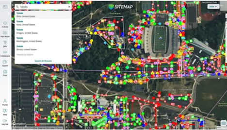
GPRS provides complimentary SiteMap Personal access to all its customers.
SiteMap also supports real-time updates, enabling project managers to track changes and modifications to subsurface infrastructure throughout the construction phase. This feature is particularly useful for large-scale projects requiring multi-team coordination and up-to-date utility data.
The Benefits of Hiring GPRS
Contractors and facilities managers who partner with GPRS for subsurface utility surveys gain several advantages:
- Improved Safety
GPRS prevents accidental utility strikes, minimizing the risk of injuries and infrastructure damage.
- Cost Savings
Accurate utility identification reduces repair costs, project delays, and legal liabilities, protecting your company’s bottom line.
- Regulatory Compliance
GPRS ensures subsurface investigations follow industry standards (SIM) and regulatory requirements.
- Project Efficiency
By delivering precise utility mapping and reporting, GPRS enables contractors to streamline planning and execution, reducing downtime.
- Cutting-Edge Technology
GPRS integrates advanced locating technologies to provide the most reliable and comprehensive subsurface data available.
Hiring GPRS for a subsurface utility survey guarantees high accuracy, safety, and efficiency. By following Subsurface Investigation Methodology (SIM), utilizing advanced equipment, and delivering comprehensive mapping via SiteMap, GPRS empowers contractors and facility managers to make confident, informed decisions. With a 99.8% accuracy rate, GPRS significantly mitigates utility strike risks, project delays, and unforeseen costs, making it a trusted partner in subsurface investigations.