The Intelligent Art of Locating Field Insights into Subsurface Investigation Methodology
SUMMARY: What appears chaotic at first is in fact a finely tuned practice rooted in precision and methodology.
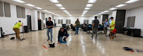
Dedicated classrooms at the GPRS Training Facility on Silica Road in Toledo, Ohio
The Intelligent Art of Locating
Field Insights into Subsurface Investigation Methodology
Savvy (noun): having or showing perception, comprehension, or shrewdness especially in practical matters; practical know-how. — Merriam-Webster Dictionary
Step into one of the four dedicated classrooms at the GPRS Training Facility on Silica Road in Toledo, Ohio, and you're immediately met with the sharp scent of concrete sealant. It clings to the air because the facility's 3,000 s.f. post-tensioned concrete slab sees relentless daily use. It is marked, scanned, and remarked by hundreds of Project Managers receiving the most rigorous training in concrete scanning & utility locating in the United States. Cleaning supplies are always on standby to clear the canvas for the next round of locates.
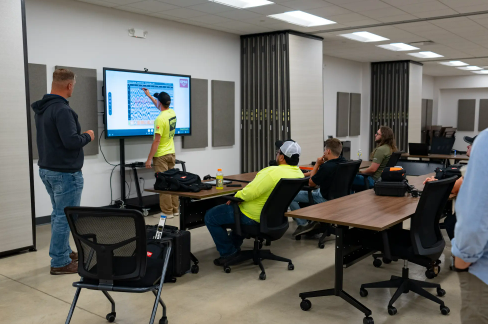
GPRS Trainer Matt Vaillant looks on as trainees learn to identify subtle differences in GPR signal outputs.
This is no standard corporate training environment. Suits are nonexistent. Instead, jeans, work boots, and ball caps serve as the uniform of choice. The space is modular: chairs and tables roll away easily, giving room for hands-on training. A large screen projects the curriculum’s technical content, and also displays hyperbolic GPR (ground penetrating radar) waveforms—visual evidence of the unseen infrastructure beneath the slab.
To an outsider, the scene might appear disordered. At any moment, a cohort of Project Manager trainees could be on their knees, maneuvering compact GPR scanners the size of a deck of cards across smooth concrete in search of concealed subsurface anomalies. But what appears chaotic is in fact a finely tuned practice rooted in precision and methodology.
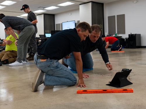
Instruction at Silica is intensely hands-on.
Their essential toolkit is minimalist: a straight edge, dry-erase markers, a digital tablet, and a handheld GPR scanner. From those basic instruments, trainees learn how to pinpoint conduit, rebar, post-tension cables, and other buried features with 99.8% guaranteed accuracy: a critical safeguard for preventing costly or life-threatening mistakes during drilling or cutting.
Instruction at Silica is intensely hands-on. Trainers like Matt Vaillant, Evan Soto, and Safety, Quality & Training Director, Mitch Streight – each a field expert in subsurface locating – guide every exercise. They eschew passive lectures in favor of immersive, boots-on-the-ground mentorship, often crouching beside their students to help interpret scan data or troubleshoot anomalies directly on the slab.
Their purpose is singular: to refine already experienced professionals into elite utility locators. The methods they teach are based on SIM (Subsurface Investigation Methodology). It’s methodical training that combines applied physics with real-world intuition to create a perfect union of science and ingenuity.
“The [Ground Penetrating Radar] scanner is dumb,” explains Vaillant. “It’s up to the person interpreting the data. You have to be savvy.”
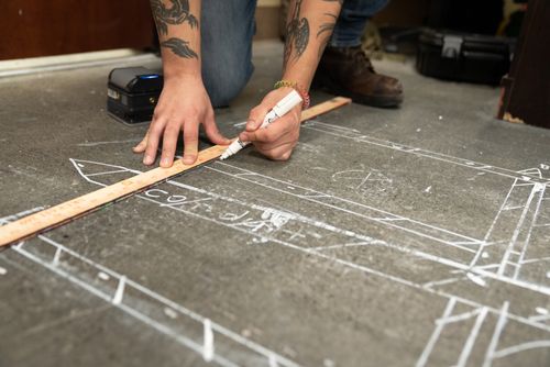
Marking out their finds in detail.
That mindset is central to SIM’s philosophy. While all trainees receive standardized instruction, i.e., how to set scan boundaries, differentiate hyperbolas, and identify critical targets, they’re also encouraged to share field-honed techniques. This reciprocal approach ensures the training stays grounded in practical relevance.
And understanding the limitations of the tool is just as essential as mastering its capabilities. Much of the curriculum focuses on nuanced adjustments: modifying scan direction, recognizing interference, and properly resetting the GPR (which, to the untrained eye, may look like erratic waving rather than scanning).
Each level of training introduces escalating challenges, from basic detection exercises to complex scenarios involving simulated elevator shafts and buried storage tanks. Lessons progress from classroom to real-world settings, including regular field deployments at partner sites like the University of Toledo.
Outdoors, Project Managers trade markers for professional-grade marking paint and incorporate additional imaging tools. The core process, however, remains consistent:
- Scan the area
- Identify subsurface infrastructure
- Confirm findings
- Mark for visibility and safety
Visual communication is key. “I want other contractors to see our marks and decide to call us because they see the detail and clean lines on what we do,” Soto emphasizes. GPRS uses strict conventions: whole numbers only (no decimals), consistent linework (//// rather than XXX), and standardized color coding by utility type to create a precise visual map of any site.
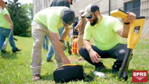
Project Manager trainees learn to use EM locators at the University of Toledo.
During a recent training cycle, one Project Manager trainee who went on to work in Detroit, Michigan reflected on the value of the experience.
“I knew more than the average PM... I learned a tremendous amount in four days that surpassed the six months I spent as a Project Coordinator.”
Outside the training rooms, camaraderie flourishes. Project Managers share lodging, swap field stories, and develop tight-knit connections that mirror the teamwork required on complex job sites. That bond is integral to the GPRS ethos.
“[GPRS] is the kind of company I really looked for, for the last seven years since I got out of the Marine Corps,” one trainee said. “I feel like I’m part of a family… Everybody here, they’ve got your six.”
At GPRS, locating isn’t simply a technical task. It is a disciplined craft that safeguards infrastructure, property, and lives. Through the rigor of the SIM training and the mentorship of seasoned trainers, GPRS continues to raise the bar in non-destructive investigation, one scan at a time.
If you’d like to learn how to join the GPRS team to Visualize The Built World™, click here.