
2026 NFL Draft Event Built on GPRS 2D & 3D Deliverables
![[Image Courtesy of Yahoo! Sports] The 2026 NFL Draft in Pittsburgh set an all-time attendance record with over 800,000 fans attending the event between April 23-25.](https://static.spacecrafted.com/acdfde82118b4e17b7a59e67b57a6ceb/i/cb26d675d64d4518913a324dacfcf88e/1/4SoifmQp45JMgBnHm9g4L/NFL%20Draft.jpg "An image of the stage and seating for the NFL Draft, Pittsburgh. An arched black ceiling supports piping and conduit with colored lighting. A blue and yellow backdrop also in the shape of an arch, is flanked and decorated with more yellow piping to look like a bridge, and the scrim displays footballs that say NFL Draft, and a Massive 2026 NFL Draft, Pittsburgh logo in the same yellow.")
[Image Courtesy of Yahoo! Sports] The 2026 NFL Draft in Pittsburgh set an all-time attendance record with over 800,000 fans attending the event between April 23-25.
By Andrew Whipple, Content Writer and Christine Potter, Content Editor, GPRS
“I thought it was an awesome experience… This is definitely the coolest job that I've done.” – GPRS Project Manager, Colton Carney
You never know where your work may take you if you’re a GPRS Project Manager. Every now and then, you get to do something super-cool: white-water raft to the base of a dam, find a long-buried time capsule in the cornerstone of a historic church, or go deep into underground mine shafts. Or, in the case of PM Colton Carney, capture the interior of Pittsburgh’s Acrisure Stadium to help set the stage for one of professional football’s biggest shows – the NFL Draft.
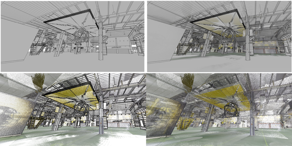
GPRS’ in-house Mapping & Modeling Team produced colorized point clouds, CAD drawings, and a Revit model to assist C3 Presents in outfitting the stadium for the NFL Draft event.
In May of 2024, the NFL selected the Pittsburgh Steelers to host the 2026 NFL Draft. That meant that event organizers like C3 Presents, needed to make some magic to transform the 24-year-old stadium’s interior and exterior to accommodate and excite the draftees, their families, and the more than 800,000 fans who watched the event.
The main part of C3’s job was erecting green rooms inside the stadium for the potential draft picks and their families to wait for their names to be called. C3 Presents also oversaw hanging large banners throughout the venue. That required knowing the layout of piping runs so they could be safely hung.
They needed precise measurements and visualizations of the space. So, they hired GPRS.

GPRS Project Manager Colton Carney is an expert in reality capture, utilizing 3D LiDAR laser scanners and photogrammetry equipment to provide highly accurate interior and exterior measurements.
GPRS Project Manager Colton Carney utilized state-of-the-art LiDAR-based 3D laser scanners to capture the inside of the Steelers’ home stadium with 2-4mm accuracy, despite his allegiance to the Cleveland Browns, Pittsburgh’s AFC North rivals.
“It was approximately 15,000 square feet of scanning,” Carney said. “We did all color scans for that. Roughly 80 to 90 scans total.” Those scans captured 2 million data points per second. Carney also captured “high-def pictures,” in 3D to allow the designers to more easily visualize the space. This kind of high definition 3D photography is known as 3D photogrammetry.
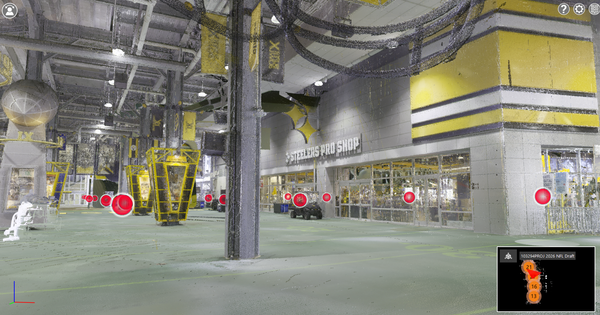
High-definition 3D photogrammetry images can be stitched together to create an accurate walkthrough tour to help designers, event staff, and engineers plan their work without needing to be on-site.
Each scan documented the stadium’s interior with 2-4mm accuracy and was automatically translated into a point cloud file.
GPRS Reality Capture Project Managers have used 3D laser scanners to accurately capture everything from historic skyscraper penthouses to dinosaur skeletons to document the site’s existing conditions for architects, engineers, VDCs, and contractors nationwide. So, even though it was exciting, scanning an NFL stadium really was “just another day at the office” for Carney.
Once scanning was completed, the point cloud was converted into 2D and 3D deliverables by GPRS’ in-house Mapping & Modeling team, which are accurate within 2-6mm, for C3’s use.
“The modeling itself was focused on the floors, the ceilings, the walls, doors, windows, stairs, elevators, ramps, etcetera,” Carney explained.
C3 Presents received a collection of deliverables which included:
The precise drawings and models let C3 Presents make better project decisions and ensure the location was ready for Draft Day while limiting the need for multiple site visits.
And PM Carney had a whole new perspective when he watched this year’s draft.
“It's pretty awesome to see the players and their families knowing that that the entire layout and floor plan of what they came up with for them and say it was from the data that we had collected that day,” he said.
GPRS Visualizes the Built World for customers across the U.S.
What can we help you visualize?
Frequently Asked Questions
1) How does utility locating work?
Utility locating works by combining an existing as-built records review, federally mandated 811 ticket coordination for registered public utilities, and field detection to identify and map buried electric, gas, water, telecom, and other infrastructure before excavation begins.
For power plants, substations, and transmission/distribution sites, GPRS supplements One Call coverage by using ground penetrating radar (GPR) to detect both metallic and non-metallic targets and electromagnetic (EM) locating to trace conductive private/unregistered and public/registered lines with 99.8% accuracy. Then they mark-out and map their findings to reduce strike risk.
GPRS Project Managers adhere to the highest industry standard – Subsurface Investigation Methodology – which means that our processes and markings are standardized, and the deliverables can include field markings plus CADD and digital utility maps in PDF, KMZ, and SHP formats delivered through SiteMap®. Click here to learn more.
2) What is RTK positioning and how much more accurate is it than GPS?
RTK positioning stands for Real Time Kinematic Positioning and is a real-time GNSS correction method that uses data from a base station or correction network to improve satellite positioning from meter-level to potentially centimeter-level accuracy.
In typical field conditions, standard GPS/GNSS is often accurate within 2-8 ft., while RTK, in perfect conditions, can achieve roughly 1-2 cm. of accuracy, making it up to 244 times more accurate than standard GPS, depending on equipment, line-of-sight, and correction quality.
GPRS has integrated RTK positioning into our utility locating workflows as a standard operating protocol to geo-reference field data more precisely for mapping and reporting. Digital access to all deliverables is provided via our SiteMap GIS platform.
3) How does GPRS maintain 99.8% accuracy in utility locating and concrete scanning?
GPRS maintains 99.8% accuracy on utility locating and concrete scanning by outfitting and training Project Managers in multiple complementary technologies and a standardized subsurface investigation process (SIM) instead of relying on a single tool.
In practice, SIM-certified field team members compare their findings from GPR and EM locating, apply repeatable field methodology and processes, and use RTK-enabled geo-referencing, a process that has allowed GPRS to maintain a 99.8%+ accuracy rate across more than one million jobs.
The protocol is Subsurface Investigation Methodology (SIM). For concrete scanning, we further back up our deliverables with GPRS’ Green Box Guarantee.
4) What other services does GPRS provide for the power industry?
Beyond utility locating, GPRS supports the power industry with concrete scanning, 3D laser scanning and reality capture, NASSCO-certified CCTV pipe inspection, pinpoint leak detection, and updated as-built documentation.
GPRS’ nationwide Field Team of Project Managers helps power utility owners/operators and transmission/distribution teams document substations and plant infrastructure, inspect buried water, sewer, or process piping, detect leaks, and produce accurate models and drawings that reduce clashes, rework, and outage-related risk.
We can custom-design deliverables to mee your needs: 2D CADD drawings, 3D BIM models, meshes, point clouds, and more, WinCan CCTV reports (including video and PACP-coded defect classifications), PDF/KMZ/SHP utility maps, delivered via SiteMap for cloud-based infrastructure visualization and secure 24/7 data access.