How Drainage Surveys Work: A Technical Guide for Municipal and Facility Managers
Routine inspections help detect early-stage issues before they escalate into backups, surface flooding, or infrastructure failures.
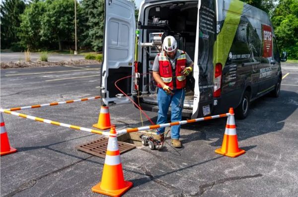
GPRS conducts drainage surveys using CCTV cameras to discover blockages and pipe defects that could impact your sewer’s efficiency.
Closed-circuit television (CCTV) drainage surveys are a foundational tool in assessing the condition and functionality of subsurface stormwater and sanitary sewer infrastructure. As part of a broader suite of sewer and stormwater inspection services, GPRS drainage surveys provide an efficient, accurate method for diagnosing issues that impair system performance—from blockages to structural damage.
GPRS Project Managers, certified by the National Association of Sewer Service Companies (NASSCO), conduct comprehensive drainage surveys using advanced camera technologies and deliver detailed WinCan reports that include video, images, and condition ratings. These reports enable maintenance and repair planning based on quantifiable, geolocated data.
Advanced Tools for Drainage Condition Assessment
GPRS employs high-definition digital cameras mounted on robotic crawlers and push-fed sewer scopes to capture real-time footage inside sewer and drainage lines. These systems are equipped with sondes—electromagnetic probes that emit a signal detectable from the surface—allowing for precise geolocation and mapping of buried lines during the inspection process.
Each inspection identifies a range of defects, including:
Root intrusion
Structural cracking or deformation
Once located, defects are documented and mapped. This eliminates the need for speculative excavation or unnecessary potholing, helping municipalities and facility managers optimize repair strategies and reduce costs.
Recommended Use Cases for Drainage Surveys
Preventive Maintenance:
Annual CCTV surveys are recommended for:
Multi-unit housing complexes
Commercial and institutional campuses
Industrial sites
Municipal sewer systems
Routine inspections help detect early-stage issues before they escalate into backups, surface flooding, or infrastructure failures.
Diagnostic Support:
Drainage surveys are essential for tracing the root causes of recurring surface flooding, particularly on roadways, parking lots, and facility grounds. They also support quality control for newly installed or rehabilitated sewer systems by verifying correct alignment, slope, and joint integrity.
Regulatory and Planning Requirements:
CCTV data supports compliance with EPA and local environmental regulations regarding stormwater management and sanitary sewer overflow (SSO) prevention. Drainage surveys can also serve as a baseline for asset management programs and capital improvement planning.
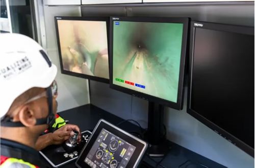
GPRS Video Pipe Inspection Project Managers deploy remote-controlled CCTV crawlers and push-fed sewer scopes to investigate sewer pipes for clogs and defects.
Why Hire a Professional Drainage Survey Firm?
While it is possible to rent or purchase CCTV drainage survey equipment, doing so presents significant logistical and financial challenges:
Rental Costs: Professional-grade crawler systems rent for $1,000+/day.
Purchase Price: Full systems often exceed $70,000.
Training Requirements: One-day video pipe inspection courses average $400 per person; two-day NASSCO certifications can exceed $925.
In contrast, GPRS offers a turnkey solution that includes certified personnel, calibrated equipment, high-resolution media, and actionable reports—all delivered with the speed and accuracy required by complex water/wastewater infrastructure systems.
Contact us to learn more about pricing and project options.
SiteMap®: Centralized Access to Survey Data and More
Collected data is only useful if your team can access it quickly and securely. That’s why GPRS integrates every drainage survey with SiteMap®, our proprietary infrastructure data platform that enables real-time access to drainage survey records, mapped utilities, and building documentation from any your smartphone, tablet, or computer, 24/7.
With SiteMap, your drainage survey can be stored alongside:
Utility locating records (99.8% accuracy)
Concrete imaging data
3D laser scans (2–4mm accuracy)
Leak detection reports
Site-specific maps and models
This centralized, interactive software allows municipal engineers, utility managers, and facility directors to visualize current infrastructure conditions and streamline communication between contractors, designers, and stakeholders.
“SiteMap® provides a single source of truth. You’re no longer relying on outdated paper maps or fragmented records,” explains a GPRS Project Manager. “You get real-time visibility into your infrastructure—anytime, anywhere.”
From Subsurface Lines to Long-Term Planning
GPRS and SiteMap® together provide an end-to-end solution for proactive infrastructure management. Whether you're troubleshooting aging sewer mains or verifying installation for new lateral connections, our services reduce uncertainty and risk while enhancing asset lifecycle planning.
GPRS Intelligently Visualizes The Built World®, supporting safer excavation, better planning, and smarter operations across both public and private sector projects.
What can we help you visualize?