GPRS Utility Mapping Enables Safe Power Line Installation Across 5.4-Mile Roadway Corridor
Two Project Managers led round-the-clock operations, overcoming heavy traffic conditions and a dense utility matrix to accurately locate and map underground utilities over a 5.4-mile stretch of urban roadway so that new power lines could be installed.

GPRS Project Managers Michael Layon (left) and Zachary Boebel (right)
A contractor tasked with boring new power lines between municipalities in the Northeastern U.S. required precise subsurface utility mapping to avoid utility strikes in a major roadway. GPRS provided comprehensive support, ensuring accurate data acquisition while maintaining safety and minimizing project delays.
Project Managers Michael Layon and Zachary Boebel led the 5.4-mile multi-city scan, conducting operations during both day and night shifts to accommodate active traffic conditions. The objective was to identify and map existing underground utilities to determine the safest and most efficient boring route.
“While scanning, I realized I was seeing double everything.” — Zachary Boebel, Project Manager
GPRS PMs worked day and night to map all the utilities through 5.4 roadway miles.
Safety Protocols in Active Roadway Environments
Surveying utilities in an active roadway environment introduces significantly higher risk than scanning closed construction zones or facility interiors. GPRS implemented enhanced safety protocols, including full traffic control measures, barricades, and coordination with local law enforcement.
“Someone, either a vehicle or pedestrian will end up in your work area,” noted Boebel. Manholes were opened throughout the route—including storm, sanitary, and electrical—requiring constant vigilance to prevent unauthorized access. Pedestrian barriers, cone zones, and visible signage were deployed to maintain work zone integrity and minimize public interference.
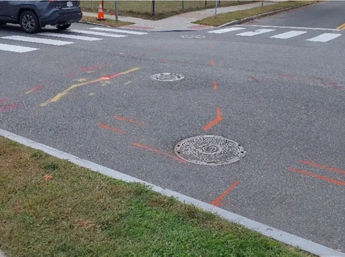
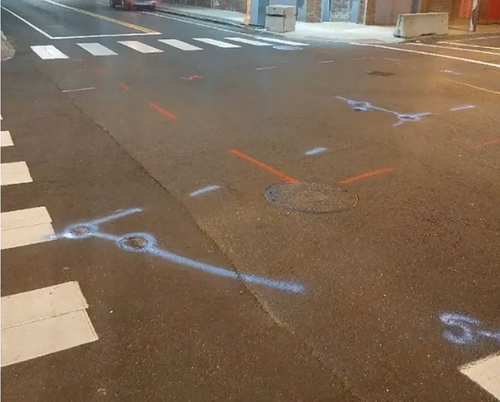
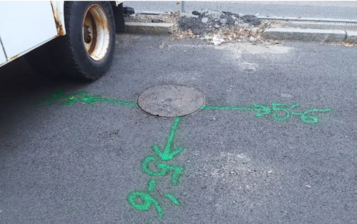
GPRS marked gas, oil, telecom, sewer, and electric and inspected every manhole.
Multimodal Utility Locating Techniques
To ensure comprehensive utility detection, the GPRS team deployed both ground penetrating radar (GPR) and electromagnetic (EM) locating technologies.
“We used every single tool at our disposal from ground-penetrating radar (GPR) to the electromagnetic (EM) locator,” said Boebel.
GPR was used as the primary method, detecting non-metallic and metallic utilities including gas lines, fiber, sewer, and electrical. EM locating complemented GPR by tracing signals from live AC power and conductive utilities, especially when direct connection to tracer wires or metal risers was feasible. This dual-technology approach provided a complete picture of subsurface infrastructure.
All GPRS Project Managers are certified in Subsurface Investigation Methodology (SIM), which ensures standardized utility mark-outs and reporting across all project types.
Differentiating Legacy Infrastructure
During the scan, Boebel encountered a unique challenge: overlapping utility systems from past and present infrastructure.
“A few years ago, a powerful tornado had flattened an entire street. And now, new houses had been built on the same property,” said Boebel. “While scanning, I realized I was seeing double everything. That’s because they had left all those old utilities, alongside new ones going to these buildings.”
The team carefully distinguished between legacy and current systems, ensuring the final deliverables reflected accurate, actionable utility data.
Scanning Beyond Scope for Complete Coverage
Although the original scope called for curb-to-curb utility mapping, field conditions demanded additional coverage. To fully trace utilities to their sources, Boebel extended scans five to six feet beyond the sidewalk, exceeding the contractor’s request to scan five feet into the grass. This proactive approach ensured utility connections were accurately located and documented.
GPRS found unexpected, abandoned utility infrastructure below the current hardened utilities, providing much-needed existing conditions to the customer.
“The customer did not have to deal with the obstacles we ran into because we took care of them,” said Layon. “We made sure we had the right team on site at the right time, allowing the customer to complete their project within the expected timeframe.”
SiteMap® Centralizes Utility Records
All utility data was uploaded to SiteMap® (patent pending), GPRS secure, cloud-based infrastructure management platform. Through SiteMap® Personal, project stakeholders accessed layered utility maps, CAD files, and other deliverables in real time—streamlining decision-making and collaboration across departments.
GPRS delivered more than field data; it provided a centralized record system that reduced the risk of utility strikes, kept the project on schedule, and enabled informed construction planning.
GPRS Intelligently Visualizes The Built World®.
To learn how we can support your infrastructure project, contact us today.