CGA Issues Targeted Recommendations to Help General Contractors Prevent Utility Strikes
The report introduces a new industry tool for tracking excavation safety progress and details actionable steps contractors and other stakeholders can take to mitigate subsurface damage risks. It supports CGA’s 50-in-5 Challenge, an initiative to reduce utility damages by 50% over five years.
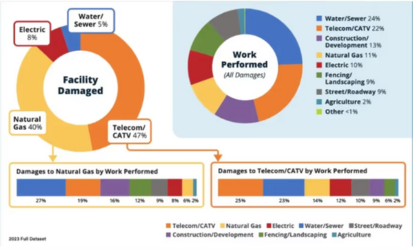
Utility Damage Data
The Common Ground Alliance (CGA) has issued a new set of recommendations aimed at reducing underground utility damages, a critical issue for general contractors managing excavation-intensive projects. These recommendations appear in the CGA’s 2023 DIRT Report, which aggregates damage incident data submitted to 811 call centers across the U.S.
The report introduces a new industry tool for tracking excavation safety progress and details actionable steps contractors and other stakeholders can take to mitigate subsurface damage risks. It supports CGA’s 50-in-5 Challenge, an initiative to reduce utility damages by 50% over five years.
“As we confront the challenge of significantly reducing damages to underground utilities, addressing the persistent top root causes demands a transformative mindset across the industry,” the report reads. “While the 2022 DIRT Report provides detailed, root cause-specific recommendations that remain relevant, the 2023 Report calls for even more decisive steps towards industry-wide improvement.”
Enhancing Data Quality and Reporting
Reliable utility damage data is essential for identifying risk patterns and informing preventative strategies. To improve data collection and submission across sectors, CGA recommends the following:
For Contractors, Locators, and Utility Owners:
- Participate in the Damage Prevention Institute and report damages monthly to enable data-driven improvements.
For 811 Centers:
- Adopt a standardized metric for "excavation readiness" to measure locate timeliness.
- Map 811 ticket information to DIRT field standards (e.g., consistent work type classification).
For All Stakeholders:
- Evaluate internal data collection practices and reduce “unknown” values in key fields such as root cause and work type.
- Apply CGA-developed tools like the DIRT root cause flow chart and Common Work Types tool for more accurate incident reporting.
- Ensure compliance with your state’s reporting rules by reviewing local regulations and training relevant staff on internal protocols.
-
Regularly review the DIRT Interactive Dashboard to inform safety outreach and risk mitigation strategies.
GPRS Supports Damage Prevention
Targeting Top Damage Drivers
Work involving water/sewer, telecommunications, and development continues to lead in reported utility strikes. CGA advises focused education and policy adjustments to address this trend:
For Contractors, Utilities, and 811 Centers:
- Launch targeted outreach programs for high-risk work categories.
- Prepare scalable protocols to handle increased excavation volumes—especially from out-of-state contractors unfamiliar with local regulations.
For All Stakeholders:
- Develop education programs that address location-specific risks across urban and rural job sites.
- Create and distribute outreach materials immediately following extreme weather events to prevent post-disaster utility damages.
- Strengthen coordination among contractors, agencies, and utility owners to reduce utility-on-utility strikes during high-volume infrastructure periods.
Improving Locating Practices
Utility strike prevention depends on accurate and timely locates. CGA outlines a series of measures to ensure that locating services keep pace with modern jobsite demands:
For All Stakeholders:
- Explore enforceable locating timelines using either monetary penalties (e.g., New Mexico) or collaborative agreements (e.g., Massachusetts).
For Facility Owners:
- Review and improve third-party locator contracts to remove time and budgetary constraints that affect service quality.
- Consider "best value" contracts that prioritize quality and accountability over lowest cost.
- Regularly engage with contracted locators to encourage proactive communication and continuous improvement.
- Invest in GPS-enabled locating equipment and allow field teams to update digital facility maps in real time. Establish QA/QC procedures to review map changes prior to finalization.
For Facility Owners, Locators, and 811 Centers:
- Analyze the relationship between 811 ticket screening protocols and locating-related damage incidents.
How GPRS Supports Damage Prevention
General contractors can mitigate their utility strike risk by working with experienced subsurface mapping professionals like GPRS. Our team provides 99.8% accurate utility locating using both ground penetrating radar (GPR) and electromagnetic (EM) locating technologies, identifying underground infrastructure before excavation begins.
All collected data is securely integrated into SiteMap® (patent pending), our project and facility management platform. SiteMap® centralizes all field-verified data—including utility locates, leak detection, concrete imaging, and 3D scans—into a single, interactive system accessible from any device.
From pre-construction planning to ongoing project coordination, this level of documentation enables contractors to reduce risk, eliminate delays, and protect budgets.
GPRS Intelligently Visualizes The Built World® to keep your projects on time, on budget, and safe.